Ag Skills Update

Precision Ag Certificate keeps students and farmers current


Kent Shannon, natural resource engineer for Missouri Extension, shows an educational teaching model of a system that can takes satellite Global Positioning System (GPS) data and makes it available to a tractor. Using this tools the farmer can push a button in the tractor cab to pinpoint its exact location to within one meter. Touching another button, the farmer displays a series of Geographical Information System (GIS) maps that shows where the soil in the field is moist, where the soil eroded over the winter and where there are factors within the soil that limit crop growth. With this data showing where the budding new crop is already thriving and areas where it isn’t, the farmer can then hit the SEND button to upload this data into an onboard applicator that automatically regulates the application of fertilizer and pesticides — just the right amount and exactly where the chemicals are needed.
Kent Shannon, natural resource engineer for Missouri Extension, shows an educational teaching model of a system that can take satellite Global Positioning System (GPS) data and makes it available to a tractor. Using this tool the farmer can push a button in the tractor cab to pinpoint its exact location to within one meter. Touching another button, the farmer displays a series of Geographical Information System (GIS) maps that shows where the soil in the field is moist, where the soil eroded over the winter and where there are factors within the soil that limit crop growth. With this data showing where the budding new crop is already thriving and areas where it isn’t, the farmer can then hit the SEND button to upload this data into an onboard applicator that automatically regulates the application of fertilizer and pesticides — just the right amount and exactly where the chemicals are needed.

An online and classroom program to train agriculture students and update professionals in the latest aspects of precision agriculture will be expanded this fall at the University of Missouri.

The program started last year with two content areas: Intro to Precision Ag and Future Trends in Precision Ag. For the spring semester 2015, Data Management and Analysis in Precision Ag, and Economics in Precision Ag will be added.

With the course additions, undergraduate students will be able to get a precision agriculture emphasis as part of their agricultural systems management degree. Persons who are employed can take the same training online and earn a certificate, which will enhance their value in the marketplace.

These three false-color images demonstrate some of the applications of remote sensing in precision farming. The goal of precision farming is to improve farmers’ profits and harvest yields while reducing the negative impacts of farming on the environment that come from over-application of chemicals. The images were acquired by the Daedalus sensor aboard a NASA aircraft flying over the Maricopa Agricultural Center in Arizona. The top image (vegetation density) shows the color variations determined by crop density, where dark blues and greens indicate lush vegetation and reds show areas of bare soil. The middle image is a map of water deficit, derived from the Daedalus’ reflectance and temperature measurements. Greens and blues indicate wet soil and reds are dry soil. The bottom image shows where crops are under serious stress, as is particularly the case in Fields 120 and 119 (indicated by red and yellow pixels). These fields were due to be irrigated the following day. Courtesy NASA.

Precision agriculture is the practice of using remote sensing, soil sampling and information management tools to improve production. It relies on technologies like satellite imagery, information technology and geospatial tools.

The goal of precision farming is to improve farmers’ profits and harvest yields while reducing the negative impacts of farming on the environment that come from over-application of chemicals.

Skills Industry is Looking For

Precision ag is used more and more in local farming operations, said Leon Schumacher, professor of agricultural systems management. “Students completing a certificate or degree program in precision ag will be more competent in their own farm operations or will be able to obtain positions such as precision ag technicians at implement dealerships, crop specialists, nutrient management specialists, precision ag department managers, precision agronomists and precision farming coordinators,” he said.

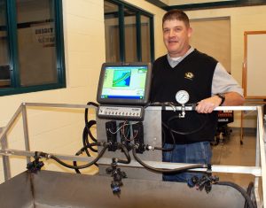
“Industry is looking for these skills,” said Kent Shannon, a natural resource engineering specialist for University Extension. “The certificate proves that they are proficient in these emerging areas.”

Schumacher said that rapid technological advances in such mapping technologies as Global Positioning Systems (GPS) and Geographical Information Systems GIS) have been a boon to agriculture, but the number of proficient practitioners has not kept up.

Agriculture With Fewer Errors

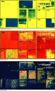
The new data management component of the training will detail how to minimize errors while collecting spatial datasets. These datasets may include yield data, soil chemical and physical properties with real-time sensors, and soil nutrient data from grids or management zones. The course then continues with a section regarding data analytical techniques such as interpolation. The second half of the course will focus on writing prescriptions based on actual data obtained from industry leader experts.

The new economics component will show how precision agriculture technology can be used to benefit a farm operation’s financial sustainability. There will be discussion of various types of farm operations and currently available technology. The course continues by considering cost factors that create barriers for farm operators to adopt precision agriculture. The second half of the course will focus on developing a plan to implement various technologies into an existing farm operation and draft a business plan for integrating GPS, GIS and other types of tracking and monitoring.

The academic courses will be offered in the same way as other university courses for enrolled students. The course for others will be offered online through University of Missouri Extension with a two-day hands-on lab.